Buckeye Caney Creek Loop Trail Guide - Ouachita Mountains of Arkansas - Ouachita National Forest
Trail Guide for the Buckeye–Caney Creek Loop - Hiking, Backpacking, and Waterfalls in Arkansas
If you’re looking for one of the best dayhiking or backpacking loops in Arkansas, the Buckeye–Caney Creek Loop in the Ouachita Mountains should be at the top of your list.
The Buckeye–Caney Creek Loop is a rugged 10-mile trail that combines big ridge views with cascading creeks, a beautiful waterfall and swimming spot, shady valleys, and some beautiful backcountry campsites.
We hiked this loop as a long day hike, and it gave us everything we love about Arkansas: steep climbs, remote wilderness, and a great swimming hole, but it could have very easily been turned into a moderate overnight backpacking trip.
Buckeye-Caney Creek Loop Summary
🧭 Trailhead: East Caney Creek Trailhead, Polk County Route 64 (Google Maps)
🗺️ Route: Polk County Route 64 —> Buckeye Trail —> Caney Creek Trail
🥾 Distance: 10 mile round-trip
📈 Elevation Gain: ~1,600 feet
⚠️ Difficulty: Easy - Strenuous day hike / Moderate backpacking trip
🗺️ GPS Information: Trail Route in GPX Format
📱 AllTrails: Buckeye Caney Creek Loop on AllTrails
Buckeye–Caney Creek Loop Basics
The Buckeye–Caney Creek Loop consists of two trails and a bit of a road walk. Both trailheads are located on Polk County Road 64. This is a rough dirt road that travels north/south from the Shady Lake Recreation Area in the south to Shady, Arkansas in the north. In places, especially between the East Caney Creek Trailhead and the Buckeye Mountain Trailhead, the road is steep and washed out and a high clearance vehicle would definitely be helpful.
In order to front-load the climbing, we began our hike of the Buckeye–Caney Creek Loop at the East Caney Creek Trailhead and walked up Polk County Route 64 the roughly 1.1 miles to the Buckeye Mountain Trailhead. From there we took the Buckeye Mountain Trail and followed it to its intersection (and end) 6 miles later with the Caney Creek Trail, which we then followed east to the eastern end of the Caney Creek Trail at the East Caney Creek Trailhead on Polk County Road 64 where the jeep was waiting for us.
Buckeye Trail Description
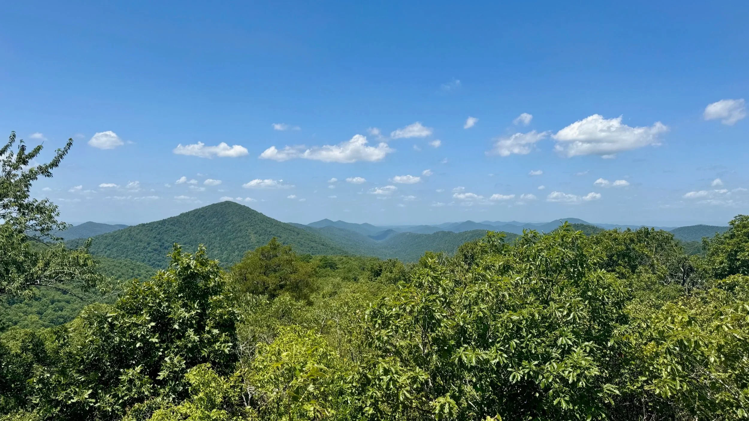
We chose to start the loop on the Buckeye Trail, which means getting the toughest section out of the way first. From the trailhead, the trail climbs nearly 1,200 feet in just over two miles. It’s a steady grind, but on good, well graded trails. Then once you reach the ridgeline, you’re rewarded with some of the best views in the Ouachita Mountains.
After the summit of Buckeye Mountain, you follow the long ridge for almost four miles, slowly descending at first and occasionally climbing gently, before beginning to descend more steeply. Along the ridge, the forest opens into long stretches of rocky ridge walking with glimpses across the wilderness. It feels remote, wild, and untouched - and we loved it. This section of trail can be dry, so make sure you carry enough water until you descend toward Katy Falls.
Near the end of the descent and before you reach the intersection with the Caney Creek Trail, you’ll come to Katy Falls - which is a must stop destination for anyone hiking this loop. In the heat of July we spent a long time swimming in the cold water, which is more than deep enough to get fully submersed. Besides the occasional crawfish who likes to nip, this place was heaven.
The intersection between the Buckeye Trail and the Caney Creek Trail is a short distance downhill from Katy Falls. Make sure you head towards the East Caney Creek Trailhead (left). The other direction on the Caney Creek Trail takes you to a totally different trailhead in a totally different area.
Caney Creek Trail Description
It’s just about four miles of hiking on the Caney Creek Trail from the trail junction to the East Caney Creek Trailhead. After the ridge walk and then steep descent, the experience shifts to a forest paths. The trail crosses the creek several times, so expect to get your feet wet, especially after rains.
Caney Creek is alive with small waterfalls, cascades, and deep pools. It’s a beautiful stretch of creek and offers plenty of opportunities to cool off in the summer.
If you’re backpacking the loop, Caney Creek is the place to camp. The valley has several flat, shaded sites right along the water, perfect for setting up your tent and relaxing after the climb on the Buckeye Trail. We almost wished we could spend the night as we hiked by.
After about two miles of hiking along the creek, the trail begins to move away from the creek and ascend gently. There are two climbs as you make your way around two shoulders of the nearby mountainsides. The first is at 8.5 miles and the second is about a half mile later at about 9 miles. There’s a short descent followed by a short climb that ends at 9.5 miles. From there to the trailhead, the trail descends the last half mile.
Why We Loved This Loop
The Buckeye–Caney Creek Loop feels like two trails in one. The Buckeye Trail delivers challenge and reward with big climbs and sweeping ridgeline views, while the Caney Creek Trail brings you into a shaded, water-filled world. Together, they make one of the most balanced and rewarding hikes we’ve taken in Arkansas.
Final Thoughts on the Buckeye-Caney Creek Loop
While we hiked the Buckeye–Caney Creek Loop in the heat of summer (we were there in late July and it was over 90 degrees), this trail is probably best enjoyed in the fall, winter, and spring seasons. Water was scarce everywhere except for along the two miles of Caney Creek and we had to be sure to carry enough water (3 liters for each of us) to climb up, over and down Buckeye Mountain to Katy Falls, which was the first place we were able to filter and refill.
As we have continued to explore the Ouachitas and Ozarks, this portion of the Ouachitas has become one of our favorite destinations. The nearby Shady Lake Campground and Recreation Area makes a great basecamp and there are a number of wild and scenic trails - including the this trail, but also the Shady Lake Loop, the Tall Peak Trail, and the nearby Eagle Rock Loop.
Tips for the Buckeye-Caney Creek Loop
Best Time to Hike: Spring and fall for cooler weather and flowing water; summer for swimming hole at Katy Falls.
Creek Crossings: Be prepared to wade, especially after heavy rains. Bring trekking poles for balance.
Navigation: Trails are generally well-marked but bring a map and GPS — this is remote wilderness.
Leave No Trace: Camping along Caney Creek is popular — please respect the sites, pack out all trash, and minimize campfire impacts.
For More Information on Hiking the Buckeye-Caney Creek Loop
You can find the Buckeye-Caney Creek Loop on:
Hikes near Buckeye-Caney Creek Loop in the Ouachitas
Gear we used on the Buckeye Caney Creek Loop:
Our Hiking Advice and Hiking Gear Recommendations
Important Hiking Considerations:
Weather: Check the weather forecast before your hike and be prepared for changes in conditions.
Safety: Some sections of trail can be steep and rocky, others can be muddy, so use caution and always watch your footing.
Leave No Trace: As with any outdoor activity, remember to follow the principles of Leave No Trace. Pack out any trash, stay on the trail, and be respectful of the natural environment.
There are so many amazing natural areas in Arkansas, no wonder it’s called the The Natural State. Join us as we explore in our Hiking Arkansas playlist on YouTube!
Some product links are affiliate links and we earn from qualifying purchases. Others are links through the Amazon Influencer program and as an Amazon Influencer, we earn from qualifying purchases. Still others, we just want you to know about some good gear we enjoy!