Eagle Rock Loop Hike - Guide to hiking one of best hikes in the Ouachita Mountains of Arkansas
Eagle Rock Loop: Arkansas' Best 30-Mile Backpacking Trail Guide
The Eagle Rock Loop in Arkansas is a 26.8-mile scenic backpacking trail in the Ouachita Mountains, and the longest loop trail in the state. The Eagle Rock Loop offers challenging climbs, multiple river crossings, and breathtaking mountain viewpoints. Popular for a 2- to 3-day backpacking trip, the Eagle Rock Loop is best hiked in spring or fall.
Coming in at about 27 miles in length, the Eagle Rock Loop hike in Arkansas is made up of a combination of several other trails including the Little Missouri Trail, the Athens-Big Fork Trail, and part of the Viles Branch Horse Trail.
The Eagle Rock Loop traverses through the southwestern portion of the Ouachita National Forest in Arkansas. Along the way, the Eagle Rock Loop has numerous river, stream and creek crossings and travels over nine separate mountains and ridges.
Eagle Rock Loop Details:
🥾 Distance: ~27 miles round trip
⛰️ Elevation Gain: ~3,880 feet
⚠️ Difficulty: Moderate to Challenging depending on pace
💦 Highlights: Epic views, Little Missouri Falls, Eagle Rock Vista, Lots of swimming
📱 AllTrails: Trail route on AllTrails app
We hiked the Eagle Rock Loop with our friend Paul, who has hiked all over the Ouachitas, and who was our guide to the area.
Since we were hiking in July, it was definitely hot for these two northern boys with daytime temperatures in the 90s and nighttime temps not much below 80 degrees — even Paul admitted a few times it was hot, so it must have been warm! When we do this hike again, we’ll definitely plan for a spring or fall hike, versus doing it again in the summertime. Still even with the heat, it was an incredible adventure and well worth the extra effort (and sweating) that it took to enjoy the Eagle Rock Loop.
We sweated a lot and watching our nutrition and hydration was key on this hike for us. Thankfully with so many water crossings, the vast majority still running even though water levels were low, we were able to stay well hydrated, and also swim and cool off at each crossing.
Overview of the Eagle Rock Loop
We hiked the roughly 30 mile Eagle Rock Loop in 2 1/2 days. We began late (5pm) on a Sunday evening at the Winding Stairs Trailhead, hiked in a few miles to a campsite just past the Albert Pike Recreation Area (heading in a counter clockwise direction on the Eagle Rock Loop). The next day was roughly 14 miles to a campsite alongside Long Creek. The last day was another 14 or so miles back to our truck at the Winding Stairs Trailhead.
Maps and Guides for the Eagle Rock Loop that we used
Both AllTrails and the FarOut App have information on the trails of the Eagle Rock Loop and in the case of the FarOut App, have a complete trail download available. We used both AllTrails and FarOut on our hike, but as we often find is the case on longer backpacking trips, FarOut wins here thanks to the more interactive tracking and the ability to get details on sites along the way (and leave your own notes for other hikers).
The next best resource for the Eagle Rock Loop is the US Forest Service’s page on the Eagle Rock Loop, which includes trail information and ranger contacts.
Detailed Trail and Backpacking Information on the Eagle Rock Loop
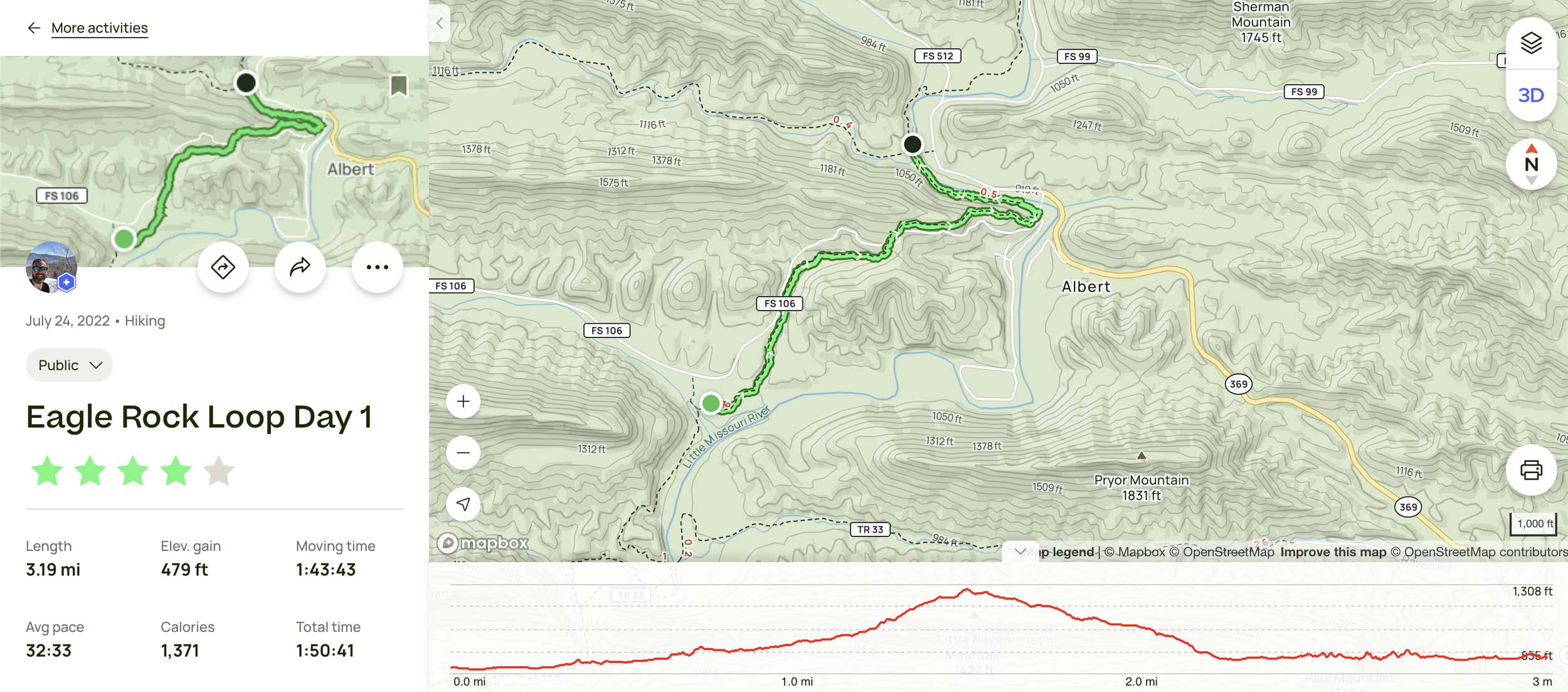
Day 1 - Winding Stairs Trailhead to campsite north of Albert Pike Recreation Area - 3 miles
From the Winding Stairs trailhead we followed a short side trail down to the intersection with the Eagle Rock Loop itself.
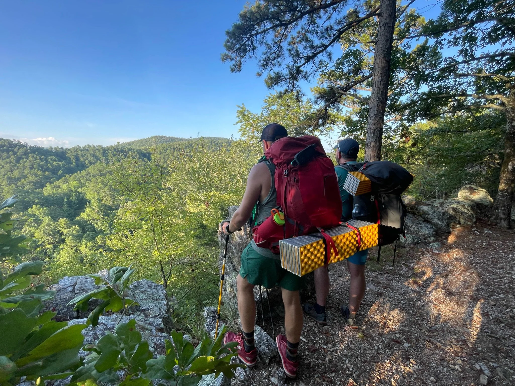
From that trail junction, we headed in a counterclockwise direction (northward) on the Eagle Rock Loop. The trail began to climb a ridge, cross a forest service road, and then crested on the ridge, where there was a view down to the river valley.
After the viewpoint, we descended down to the Albert Pike Recreation Area, which we walked through, and began following the Little Missouri River upstream along the trail. About two miles after the Albert Pike Recreation Area we found a campsite and made camp for the night.

Day 2 - Campsite north of Albert Pike Recreation Area to Long Creek - 14 miles
We broke camp in the morning and continued counterclockwise on the Eagle Rock Loop.
For most of this section, the trail follows an old road, making the walking relatively easy. The trail climbs gradually following the Little Missouri River. You pass by Little Missouri Falls and then continue following a fairly gentle route to the intersection with the Athens-Big Fork Trail.
Here the Eagle Rock Loop crosses the now very small, Little Missouri River, leaves the old road it was following, and then follows the Athens-Big Fork Trail south over a series of mountain ridges. We continued on the Athens-Big Fork Trail over Hurricane Knob and over the next ridge, before making camp at a campsite alongside Long Creek.
The climbs up and over those two ridges was defintely more difficult than the hike prior to them, but again, compared to eastern hiking, the treadway was well maintained and the slope of the climbs were not overly difficult.

Day 3 - Long Creek to Winding Stair Trailhead - 14 miles
After breakfast and breaking camp at Long Creek, we got on our way to continue south crossing ridges until we reach Viles Branch Trail and head eastward towards the Winding Stairs area.
The worst of the climbs was the trek up and over Brush Heap Mountain, which was steeper and more direct then the other climbs, but wasn’t overly difficult - just a real slog with it being so hot.
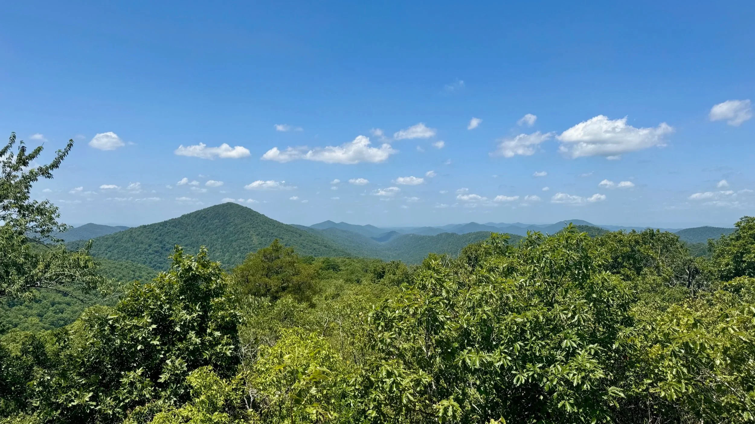
On the last ridge is the Eagle Rock vista, which is on a side trail off the main trail, but well worth the few tenths of a mile. From there it was down to the Viles Branch Trail and then we followed the Viles Branch to the trail junction with the Little Missouri/Winding Stairs Trail.
Once on the Little Missouri/Winding Stairs Trail, you are again following alongside the Little Missouri River and you travel through the Little Missouri’s gorge through the Winding Stairs area. There are several awesome swimming holes in this section. From there, the trail climbs up and away from the Little Missouri before we came back to the side trail to the Winding Stairs Trailhead.
Eagle Rock Loop FAQ
What is the Eagle Rock Loop?
The Eagle Rock Loop is a 30-mile backpacking trail in Arkansas, considered the longest loop hike in the state. It winds through the Ouachita Mountains, combining three trails: the Little Missouri Trail, the Athens-Big Fork Trail, and the Viles Branch Trail.
Where is the Eagle Rock Loop located?
The Eagle Rock Loop is located in the Ouachita National Forest of southwestern Arkansas, near the towns of Glenwood and Mena.
How difficult is the Eagle Rock Loop hike?
The Eagle Rock Loop is rated as challenging due to steep climbs, multiple river crossings, and rugged terrain. It's recommended for experienced backpackers.
How many days does it take to hike the Eagle Rock Loop?
Most hikers complete the loop in 2–3 days, depending on pace, weather, and river conditions.
Is the Eagle Rock Loop hike well-marked?
Yes, but hikers should still carry a map or GPS. Trail markers can be sparse in some areas, and river crossings can obscure the route. You should download the FarOut Guide for the Eagle Rock Loop and/or the AllTrails information for the Eagle Rock Loop.
Is there cell service on the Eagle Rock Loop
The only cell service on the Eagle Rock Loop is at the Eagle Rock Vista and a few of the other mountain summits. Otherwise there is no service.
For More Information
For more information on the Eagle Rock Loop Trail, the National Forest Service maintains a really good web page that includes trail descriptions and maps. We also utilized the FarOut app, which includes the Eagle Rock Loop as a paid trail download. AllTrails also included info on the Eagle Rock Loop.
You'll also notice no one seems to agree on the total distance. We had a touch over 30 miles when all was said and done, but that included the side trips that we took to view points and swimming spots.
A heads up that the water crossings on the Eagle Rock Loop can be difficult, if not impossible at higher water levels, so it's important to check water levels before beginning your hike of the Eagle Rock Loop.
Backpacking and Hiking Gear We Used on the Eagle Rock Loop
Hydration and nutrition for this hike:
Our Hiking Advice and Hiking Gear Recommendations
(Product links are affiliate links, so if you purchase something through them, it helps us out)
Trail Tip! If you’re looking for a smartwatch that will stand up to the rigors of hiking and backpacking, while still looking good for everyday wear, the Garmin Instinct is an amazingly rugged watch with great battery life that has provided us with years of good service and is still going strong. We consider it the best all around hiking watch.