Five Minute Video Guide to Hiking the Eagle Rock Loop
Hiking the Eagle Rock Loop - A Quick Overview
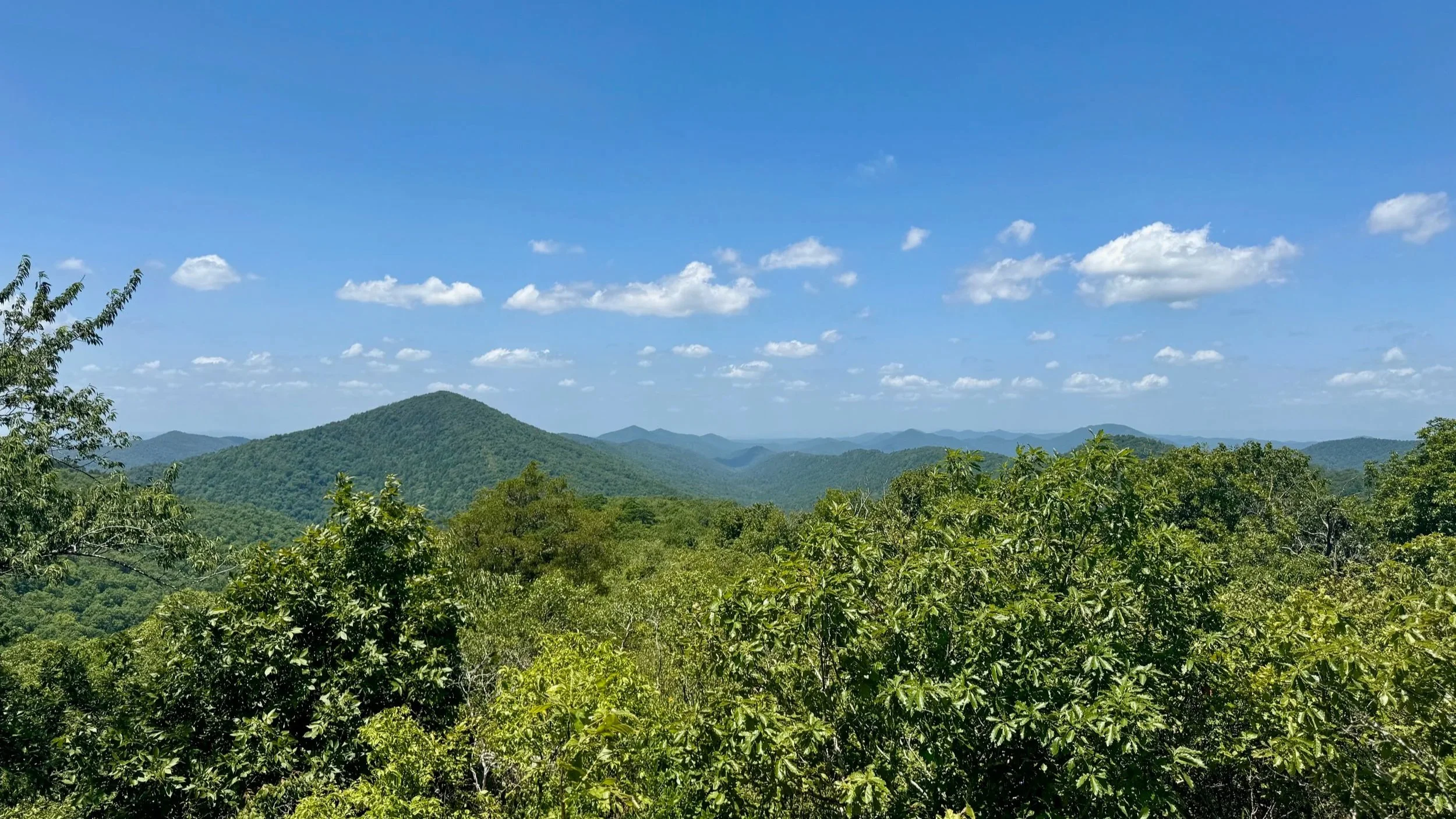
The Eagle Rock Loop in Arkansas is a roughly 30 mile scenic backpacking trail in the Ouachita Mountains, and the longest loop trail in the state. The Eagle Rock Loop offers challenging climbs, multiple river crossings, and breathtaking mountain viewpoints. Popular for a 2- to 3-day backpacking trip, the Eagle Rock Loop is best hiked in spring or fall.
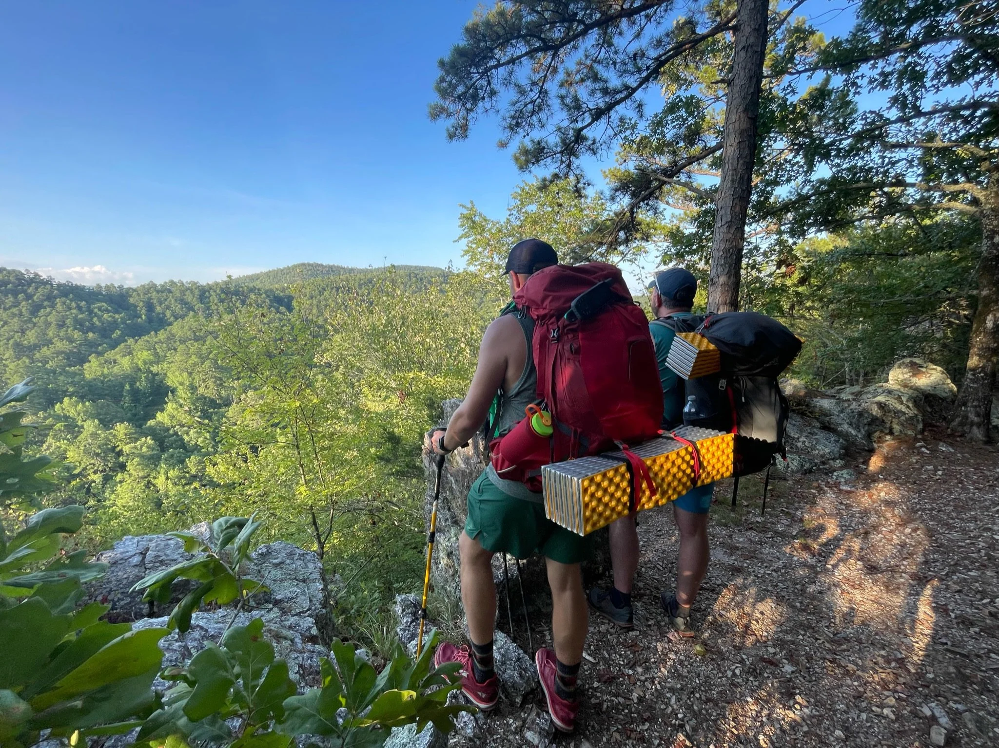
By far, one of our favorite hikes in Arkansas as we have come to explore the state is the Eagle Rock Loop, a 30 mile loop hike in the Ouachita Mountains of Arkansas. The Eagle Rock Loop is not a single trail, but is made up of a combination of several trails including the Little Missouri, the Athens-Big Fork, and part of the Viles Branch Horse Trails.
The Eagle Rock Loop is located in the southwestern portion of the Ouachita National Forest. Along the way, the Eagle Rock Loop has numerous river, stream and creek crossings and travels over nine mountains and ridges. Some of the water crossings on the Eagle Rock Loop can be difficult, if not impossible at higher water levels, so it's important to check those before beginning your hike. The most difficult crossings involve the Little Missouri River near the junction of the Viles Branch and Little Missouri Trails.
We hiked the 30 mile Eagle Rock Loop in 2 1/2 days. We began late (5pm) on a Sunday evening at the Winding Stairs Trailhead, hiked in a few miles to a campsite just past the Albert Pike Recreation Area (heading in a counter clockwise direction on the Eagle Rock Loop). The next day was roughly 14 miles to a campsite alongside Long Creek. The last day was another 14 or so miles back to our truck at the Winding Stairs Trailhead.
For experienced hikers, we could see this hike easily being a two day hike (if you’re able to get an early start). For even more experienced hikers, it would be possible to do the Eagle Rock Loop as a single long day. We’d suggest not in the summer though - that’s what really made us slow down and take it somewhat easy for the backpacking trip. For northerners like us, the heat was oppressive at best in July.
Eagle Rock Loop FAQ
What is the Eagle Rock Loop?
The Eagle Rock Loop is a 30-mile backpacking trail in Arkansas, considered the longest loop hike in the state. It winds through the Ouachita Mountains, combining three trails: the Little Missouri Trail, the Athens-Big Fork Trail, and the Viles Branch Trail.
Where is the Eagle Rock Loop located?
The Eagle Rock Loop is located in the Ouachita National Forest of southwestern Arkansas, near the towns of Glenwood and Mena.
How difficult is the Eagle Rock Loop hike?
The Eagle Rock Loop is rated as challenging due to steep climbs, multiple river crossings, and rugged terrain. It's recommended for experienced backpackers.
How many days does it take to hike the Eagle Rock Loop?
Most hikers complete the loop in 2–3 days, depending on pace, weather, and river conditions.
Is the Eagle Rock Loop hike well-marked?
Yes, but hikers should still carry a map or GPS. Trail markers can be sparse in some areas, and river crossings can obscure the route. You should download the FarOut Guide for the Eagle Rock Loop and/or the AllTrails information for the Eagle Rock Loop.
Is there cell service on the Eagle Rock Loop
The only cell service on the Eagle Rock Loop is at the Eagle Rock Vista and a few of the other mountain summits. Otherwise there is no service.
Full Hiking Guide and Video to the Eagle Rock Loop
In addition to this short video and guide, we have written an in-depth guide and produced a detailed video for the Eagle Rock Loop hike that will provide you with much more information about the Eagle Rock Loop hike.
For More Information on the Eagle Rock Loop
We have a more in-depth written guide and video for the Eagle Rock Loop hike.
The National Forest Service maintains a really good web page for the Eagle Rock Loop that includes trail descriptions and maps.
For our hike of the Eagle Rock Loop, we utilized the FarOut app, has an Eagle Rock Loop map as a paid trail download.
AllTrails also included info on the Eagle Rock Loop.
You'll notice no one seems to agree on the total distance. We had a touch over 30 miles, but that included the side trips that we took to view points and swimming spots.
A heads up that the water crossings on the Eagle Rock Loop can be difficult, if not impossible at higher water levels, so it's important to check those before beginning your hike
Backpacking Gear We Used
Hydration and nutrition for this hike:
Our Hiking Advice and Hiking Gear Recommendations
Some product links are affiliate links and we earn from qualifying purchases. Others are links through the Amazon Influencer program and as an Amazon Influencer, we earn from qualifying purchases. Still others, we just want you to know about some good gear we enjoy!
Important Hiking Considerations:
Weather: Check the weather forecast before your hike and be prepared for changes in conditions.
Safety: Some sections of the trail can be steep and rocky, so use caution and watch your footing.
Leave No Trace: As with any outdoor activity, remember to follow the principles of Leave No Trace. Pack out any trash, stay on the trail, and be respectful of the natural environment.